Indian Ocean Tsunami Helps Geologist Revise Models
by Chris Bryant
The 2004 Sumatra tsunami that killed some 280,000 people along opposite shores of the Indian Ocean was one of the most devastating natural disasters in recent history. It may also prove to be a great teacher, says Dr. Timothy Masterlark, a University of Alabama geologist who was among the first to survey the origin of the massive, tsunami-triggering earthquake, deep beneath the Indian Ocean.
Because earthquakes of this size – a magnitude 9+ – only happen once every 30 to 40 years, Masterlark said the quake may provide the most earthquake information this generation of scientists will ever see. During earthquakes, several processes, each with a signature effect, occur. With smaller quakes, those effects are less visible and thereby those processes that occurred are more difficult to study.
“We have this massive earthquake, as big as they get, and we have modern instrumentation in place to measure those effects and record what’s still going on today,” Masterlark said. “We can’t stop the forces that drive earthquakes. The best we can do is to try to understand them.”
Actually, Masterlark has hopes that one day scientists will take such an understanding to an entirely different level…the level of earthquake prediction.
“We can’t predict earthquakes right now, with our current understanding,” Masterlark said. “If we learn enough about the Earth, maybe we can, some day. I think we’ll get to this, it’s a matter of time.”
Although some scientists are skeptical such predictions will ever become accurate enough to be useful, Masterlark points out that not so long ago hurricane predictions also seemed impossible.
The assistant professor of geological sciences, within UA’s College of Arts and Sciences, develops mathematical models to depict how the Earth shifts during a quake.
“Because we know the physics behind rock behavior, we can simulate earthquakes with mathematical models and predict how the Earth’s crust will respond.”
Masterlark’s modeling efforts have attracted NASA’s attention, with the space agency awarding him $323,000 in funding over three years to further refine his mathematical models.
NASA’s interest comes from Masterlark’s use of Global Positioning Satellites, or GPS, which measure how points on the Earth’s surface move during quakes.
“An additional part of the NASA project is to explore how we can use other types of satellite imaging other than GPS.”
Although scientists can see, through the imaging, how points on the Earth’s surface move during a quake, they can’t, of course, see this shift in depth, such as miles below the Indian Ocean.
When complete, Masterlark’s model, developed to solve a set of differential equations, will predict how the seafloor moves. He will then share his earthquake model with tsunami modelers who will, in turn, use the seafloor movement predictions to generate tsunami propagation models and account for the observed onshore destruction.
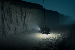
The UA scientist got a first-hand view of the area he is modeling some six months after the tsunami and its 100-foot waves came crashing ashore on the lands surrounding the Indian Ocean. He was part of a 27-person scientific team who surveyed the ocean floor while a Discovery Channel television crew filmed the operation. The crew spent two weeks at sea aboard a research vessel. Sound waves were used to map the seafloor surrounding the quake’s point of origin and a remote submersible equipped with video cameras beamed back images to the scientists.
Members of the expedition were surprised by what they saw. The deformities the quake caused in the seafloor were not expected. “Our expectations were dead wrong,” Masterlark said. “Theoretical models had predicted one thing, and we observed something else. I began to make new conceptual models that tried to account for what we were seeing.” Being wrong isn’t so bad, Masterlark says, when you can learn from it. Being wrong and not knowing it is what is dangerous.
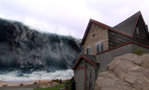
Better understanding of the gigantic tsunami that destroyed lives in Sumatra, Sri Lanka, India and Thailand may lead to accurate prediction methods that save others.
WHAT CAUSES TSUNAMIS?
By Timothy Masterlark
Tsunamis, referred to more commonly (but incorrectly) in years past as tidal waves, result from underwater earthquakes.
Earth’s rigid outer layer, the lithosphere, is divided into more than a dozen huge pieces called tectonic plates. The plates move with respect to one another — on average, a few inches per year. This relative motion causes a buildup of stress along plate boundaries, or faults. An earthquake is the occasional release of the built up stress.
The fault of the 2004 M9 Sumatra-Andaman earthquake slipped 60 feet and released an enormous amount of stress that had been building up for centuries.
Earthquakes cause two types of deformation. Dynamic deformation is temporary and takes the form of seismic waves, or shaking. Static deformation is the permanent shift of the ground that remains after the seismic waves have passed. This type of deformation causes little damage for onshore regions and can be measured by satellites. For offshore regions, the immeasurable static deformation changes the shape of the seafloor, which in turn, disturbs the ocean surface — the birth of a tsunami.
The solid seafloor maintains the deformed shape, however, the fluid ocean responds by propagating tsunami waves away from the initial disturbance. The relatively small tsunami waves, which may initially be only a few feet tall in the deep ocean, can travel at speeds of several hundred miles per hour in deep water. However, the speed of the waves drops dramatically as the depth to the seafloor decreases.
The dependence on speed causes the waves to get much bigger as they approach coastal areas, because the water at the front of the waves is moving slower than the water at the back of the waves, and water piles up on itself. This effect is responsible for the 100-foot tsunamis that overwhelmed the coastal areas of Sumatra, even though the disturbance initially triggered by the M9 Sumatra-Andaman earthquake was only a few feet tall.
Further Reading